WASHINGTON STATE PARK · CHUCKANUT
Larrabee State Park
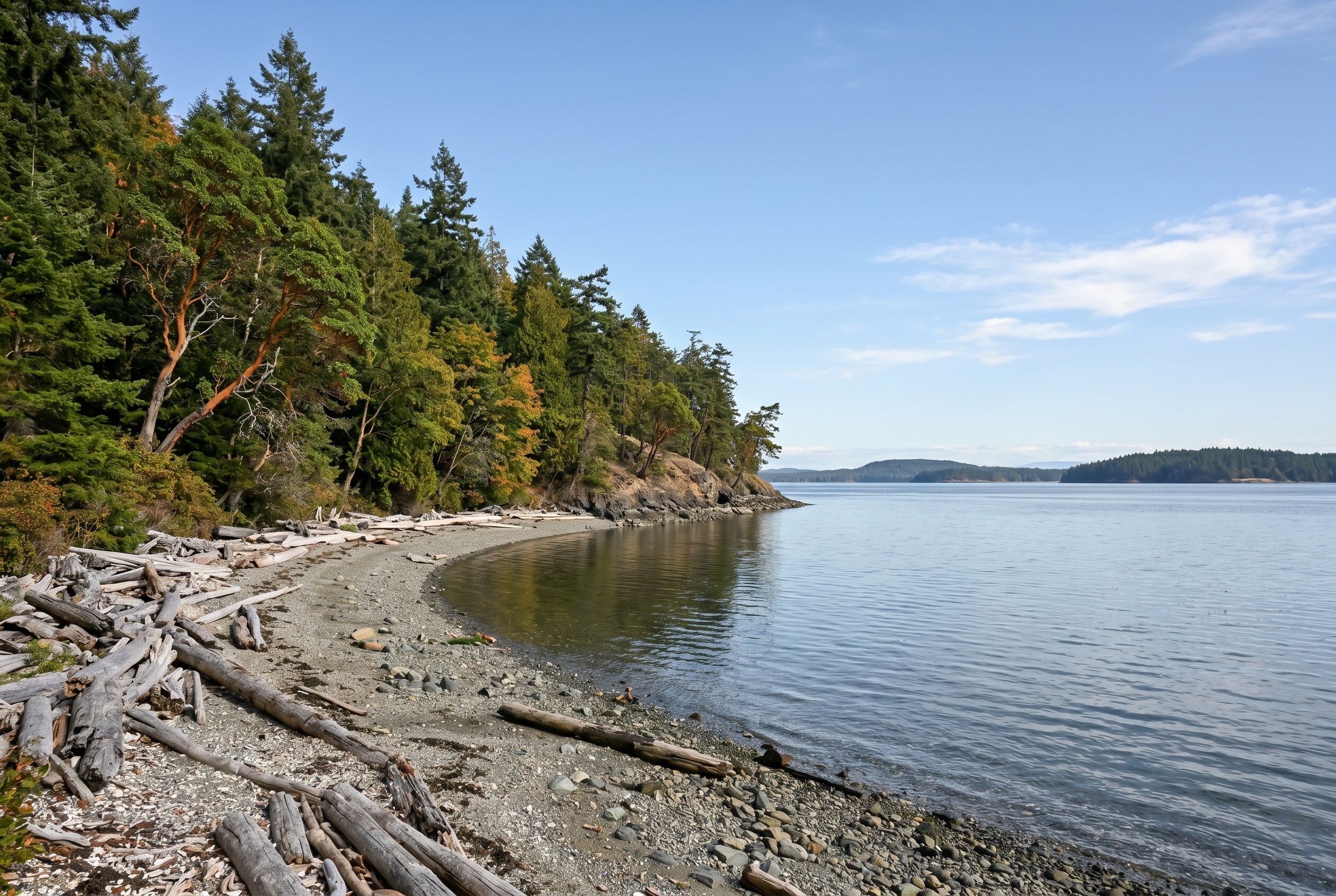
Washington’s first state park sits seven miles south of Bellingham, where Chuckanut Mountain drops straight into Samish Bay. Sandstone tidepools, two mountain lakes, and roughly 2,700 acres of forest and saltwater.
The basics
Size
2748 acres
Established
1915
I have lived and sold real estate in Whatcom County long enough to have a short list of places I take people when I want them to understand why folks move here and stay. Larrabee State Park is near the top of that list. It is about seven miles south of Bellingham on Chuckanut Drive, the old cliff-hugging two-lane that everyone tells you to drive at least once. The park covers roughly 2,748 acres with about 8,100 feet of saltwater shoreline, and it stacks a working campground, two freshwater mountain lakes, a boat launch, miles of trail, and genuine tidepools into one place. It also carries a title nobody can take away from it: this was Washington’s first state park, established in 1915. I am not going to oversell it. Parking gets tight on a sunny Saturday, the beach access involves crossing an active rail line on a bridge, and the boat ramp is only really usable around high tide. But on a quiet weekday morning, with the tide out and the San Juans floating on the horizon, it is one of the best free-with-a-pass things to do in the whole county. This guide covers the history, the tidepools and Clayton Beach, the Fragrance Lake and Lost Lake trails, camping, boating on Samish Bay, the Discover Pass and parking, when to go, and what it is like to live along Chuckanut. Where a number is fuzzy or sources disagree, I will say so rather than make something up.
Washington’s first state park: the 1915 story
Larrabee gets called Washington’s first state park, and as far as I can tell that is accurate rather than marketing. The short version: in 1915, Governor Ernest Lister was pushing the idea of grabbing small tracts of land along the new state highways so travelers had somewhere to stop. On November 22, 1915, the Washington Board of Park Commissioners accepted a 20-acre donation from Frances Larrabee, the widow of Charles Xavier Larrabee, and that parcel became the state’s inaugural park. It was originally called Chuckanut State Park, after the nearby bay, and was renamed to honor the Larrabee family on February 15, 1923. State Parks’ own history notes that Frances actually objected to the renaming, which is the kind of human detail I like better than a plaque. Charles Larrabee himself was a Fairhaven figure tied to the early development of the area, and he was a champion of Chuckanut Drive back when it was a logging road being lobbied into a highway. That road got legislative funding starting around 1909 and was folded into the Pacific Highway by 1913, which is the whole reason a scenic park out here made sense in the first place. The park did not stay 20 acres. The Larrabee family donated a large additional chunk of land in 1937, which is how a tiny roadside stop grew toward the size it is now. During the Depression, federal money went into the park as well; Washington State Parks and Wikipedia both reference Works Progress Administration funding in the mid-1930s, including a figure of around 30,000 dollars in 1936 for improvements like water systems and playground equipment, plus a railroad underpass that opened in 1935. There is also a distinctive bandshell or amphitheater on the grounds, attributed to architect Earle E. MacCannell and dated to 1944. I would treat the exact dollar figures and dates as ‘roughly right per the public histories’ rather than gospel, but the broad arc is well documented. The land itself sits within Coast Salish territory, and the name Chuckanut comes from an Indigenous term. I mention that because the 1915 ‘first park’ framing is a settler-era milestone laid over a place that people knew and used for a very long time before any of it was donated.
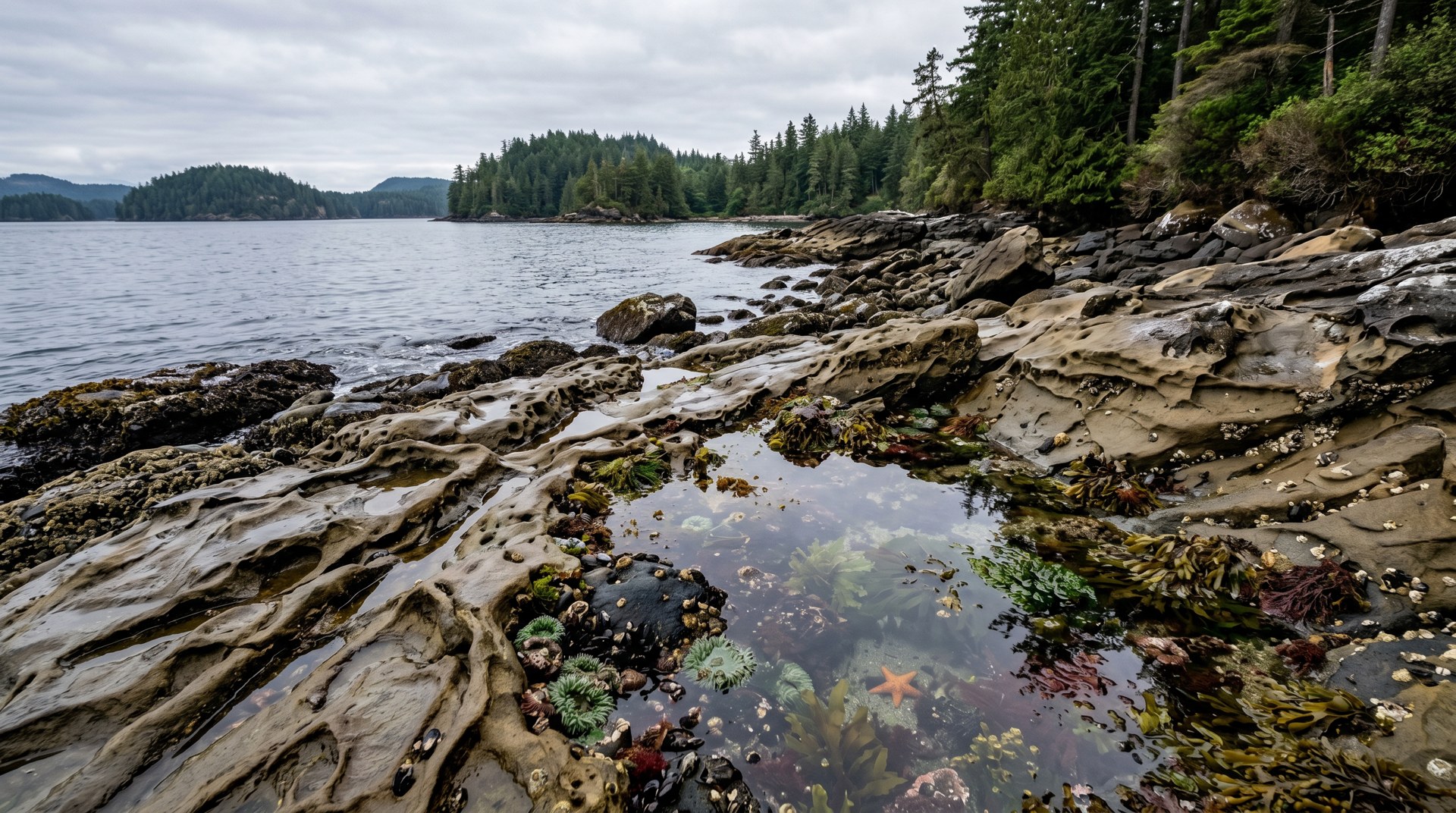
Tidepools, sandstone, and Clayton Beach
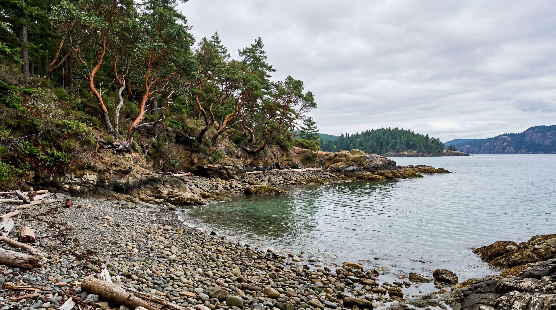
The shoreline is the reason I send first-time visitors here over a dozen other parks. Larrabee has real saltwater tidepools, not a token patch of rocks. The headline spot is Wildcat Cove, down near the main day-use area, where the Chuckanut sandstone has been carved by weather and waves into the honeycombed, swirled shapes the area is known for. At a good low tide you can walk out among the pools and find the usual Salish Sea cast: anemones, crabs, barnacles, the occasional sea star. The single most important thing I tell people is to check the tide chart before you drive out. A high tide hides almost all of it; the magic only happens when the water pulls back, so plan your visit around a low minus tide if you can. The other shoreline destination is Clayton Beach, and this one has a real story attached to it. For decades, getting to Clayton Beach meant scrambling across an active Burlington Northern Santa Fe rail line on a blind curve, which was exactly as sketchy as it sounds. State Parks acquired the Clayton Beach land, over 100 acres, back in 1988, but the safe-access piece took a long time. In 2023 a new trail and a fenced pedestrian overpass bridge finally opened, so you now walk over the tracks instead of risking them. The Clayton Beach trail runs roughly three-quarters of a mile from the Lost Lake parking lot through mixed forest, with a few sets of stairs and some gravel, then drops down to the sand. The beach itself is on the order of a quarter-mile long, backed by more of that sculpted sandstone, with open views across Samish Bay toward the San Juan Islands. It is one of the few genuinely sandy beaches in the area, which is a big part of its appeal. A couple of honest caveats. It is still a state park beach, so no fires where prohibited, and dogs are on-leash. The walk down is easy; the walk back up, with kids and beach gear, is the part nobody photographs. And because that overpass replaced an informal crossing, do not go looking for the ‘old way’ across the tracks. Use the bridge. The whole reason it exists is that the at-grade crossing was dangerous.
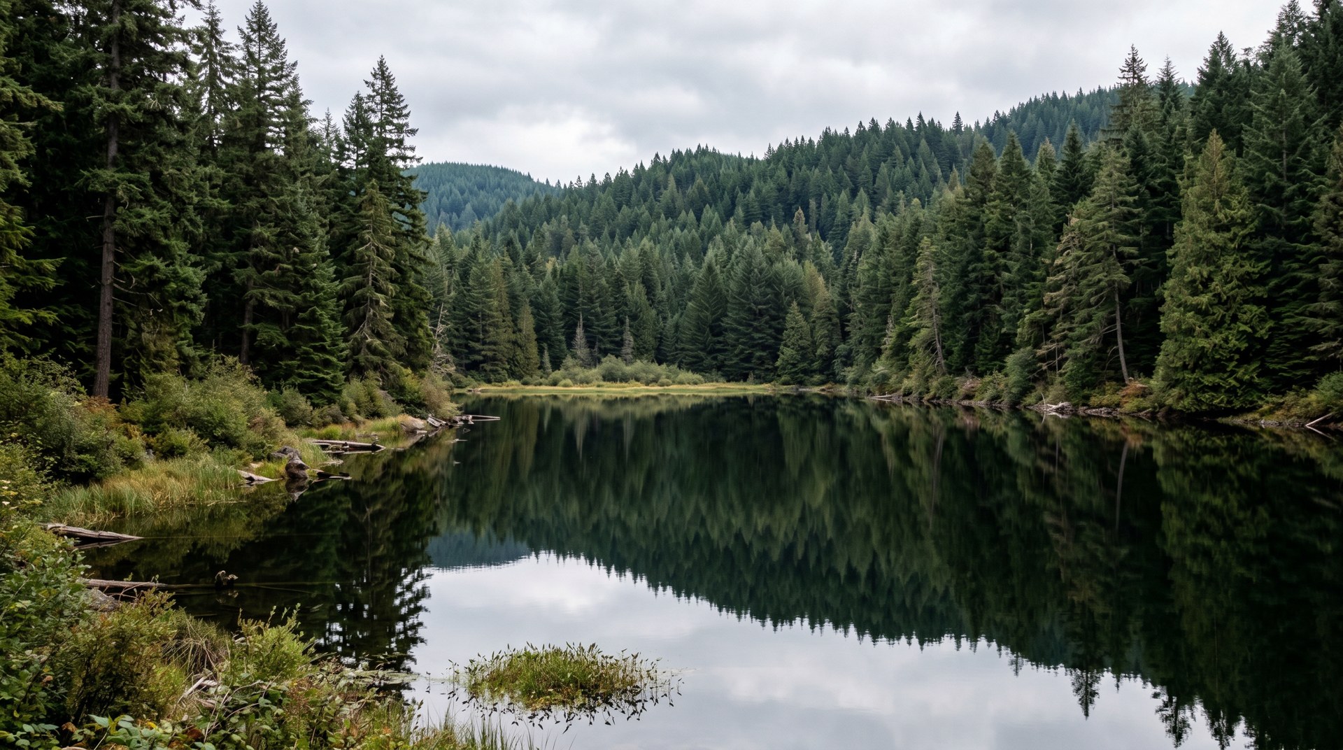
Fragrance Lake and Lost Lake: the trail system
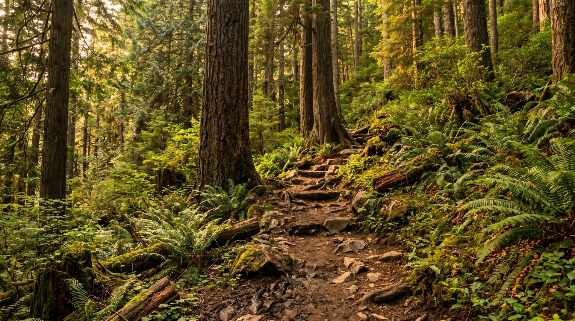
Larrabee is not just a beach park, and that surprises people. There is a substantial trail network climbing the seaward side of Chuckanut Mountain. State Parks describes the park as having around 18 miles of trails, broken into roughly 1.5 miles of bike-only trail, 2.7 miles of hiking-only trail, and about 13.8 miles of multi-use trail. You will see other tallies in the 13-to-15-mile range from third-party sources, so treat the exact figure loosely, but the point stands: there is a lot here. The classic hike is Fragrance Lake. It is a moderate climb from a trailhead right on Chuckanut Drive, more or less directly across from the park’s main entrance. Mileage and elevation gain depend on who you ask. Washington Trails Association lists it as about 4.0 miles round trip with roughly 1,260 feet of gain to a high point near 1,190 feet, while other trail apps put it closer to 4.4 miles and about 1,060 feet. Either way, plan on a couple of hours of real uphill, rewarded by switchbacks through tall second-growth and old forest. About a mile up, a short spur breaks off to a viewpoint over Samish Bay and the San Juans that is worth the detour. At the top there is a quiet little lake with a flat 0.6-mile loop around the shoreline, big mossy boulders on the west side, and the deep evergreen smell that presumably gave the lake its name. Lost Lake is the bigger, more committing objective. Strong hikers can push past Fragrance Lake on toward Lost Lake, adding somewhere around 5.5 miles and another 800-plus feet of climbing per WTA, so the full out-and-back becomes a serious day. There is also a network connection here worth knowing: the Interurban Trail, an easy, mostly flat former rail grade, runs about 6.6 miles between Fairhaven and Larrabee and ties into this trail system, with trailheads at Fairhaven Park, Arroyo Park, and the state park itself. That is how people string together a long walk or ride from town all the way to the park. Mountain biking is allowed on the designated bike and multi-use trails, which makes Larrabee and the surrounding Chuckanut trails a legitimate riding destination, not just a hiking one. Heads up on one practical issue: timber and trail work happens out here. State Parks has run logging and forest-health projects that temporarily affected the Lost Lake area and parking, so before a long day check the park’s alerts page for closures. I have driven friends out to a trailhead that turned out to be roped off, and it is an easy thing to avoid with a thirty-second check.
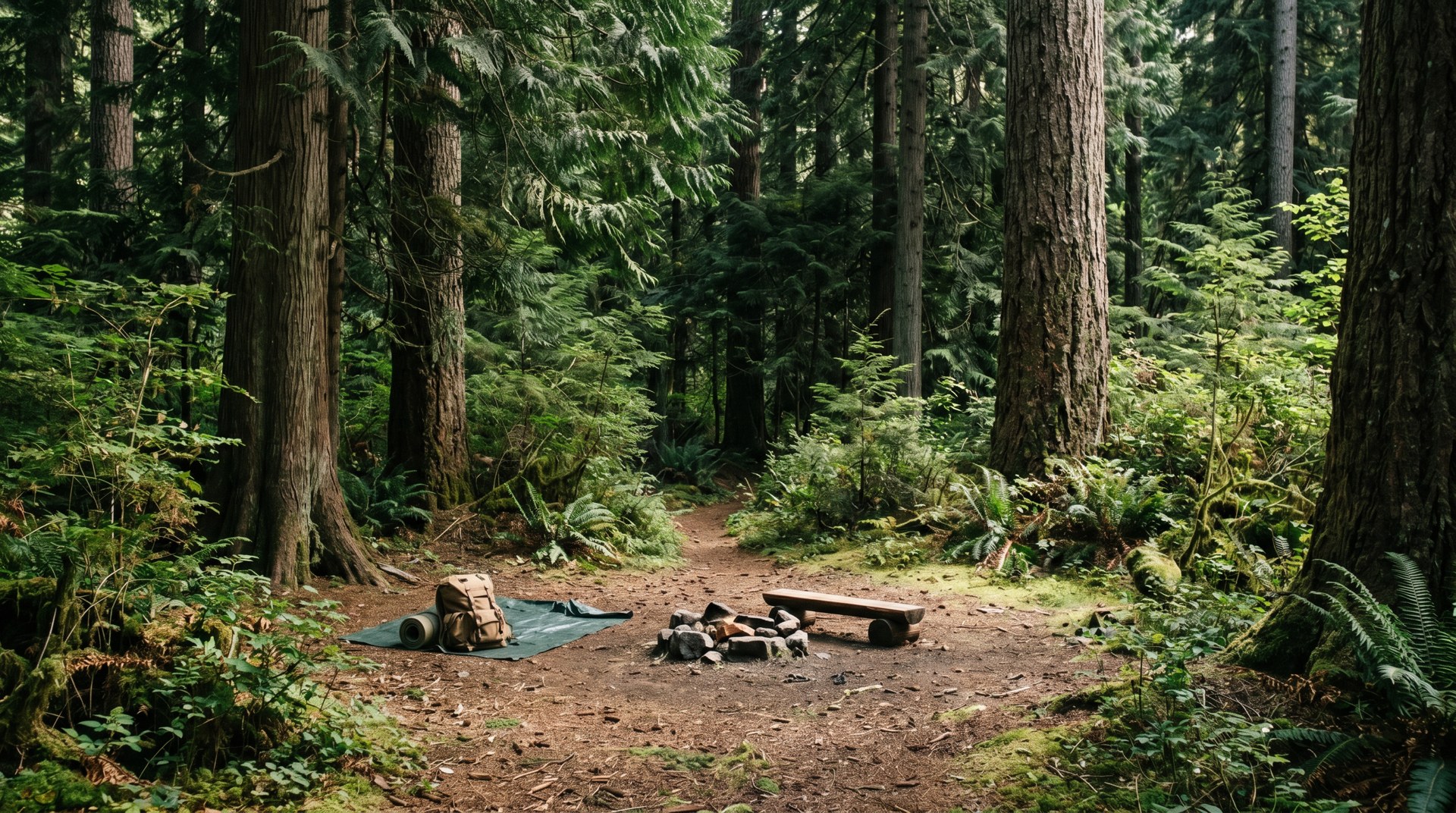
Camping: tent, RV, and the reservation reality
Larrabee is a real campground, and a popular one, so this is where the planning matters most. Per Washington State Parks, the campground has 51 standard tent sites, 26 utility (hookup) sites, and eight primitive sites, plus one dump station and six showers. There are two ADA-designated campsites, listed as sites 50 and T14. Check-in is 2:30 p.m. and check-out is 1 p.m. That mix tells you who it works for: tent campers, RVs needing hookups, and folks who want a no-frills primitive spot. It is forested camping a short drive or walk from saltwater, which is a combination people will pay and plan ahead for. Here is the honest part. In summer, you do not just show up and grab a site. Sites become reservable up to nine months in advance, and the peak window roughly mid-May through mid-September fills early. If you have your heart set on a weekend in July, get on the reservation system the moment your dates open, nine months out, or be ready to take a weekday or a shoulder-season date instead. I have had clients visiting from out of state assume they could road-trip up and find a spot on a Friday in August, and that is not a bet I would make here. A few more practical notes. This is a Discover Pass park, but overnight campers’ fees are handled through the camping reservation, so a paid campsite covers your vehicle while you are registered, you do not also need a separate day-use pass on top of a paid night. Cell service along Chuckanut is spotty, so download your reservation and any maps before you lose signal. And because the park hugs a mountain over the water, some sites are more sloped, shaded, or tucked-in than others; if that matters to you, read the individual site notes when you book rather than picking by number alone. Group camping and day-use shelters exist for larger gatherings and reunions, but availability and exact group-site details are best confirmed directly with the park, since those bookings work differently than individual campsites.
Boating, crabbing, and Samish Bay
The water side of Larrabee is genuinely useful, with one big asterisk. There is a boat launch at Wildcat Cove, and from here you are putting in on Samish Bay with the San Juans spread out in front of you. People use it for fishing, crabbing, clamming, and diving, and on a calm day it is a beautiful, protected-feeling stretch of water to paddle or run a small boat. The asterisk is tides. State Parks is direct about this: the launch is usable at high tide and may be inaccessible at low tide, because Wildcat Cove is shallow. So unlike a deep-water marina ramp you can use whenever, launching here is a tide-window activity. If you are towing a boat out, plan your trip around the high tide, not just your own schedule, or you may arrive to find the ramp high and dry. For kayaks, canoes, and paddleboards the constraint is softer, you can hand-carry over more of the tide range, but you still want to know what the water is doing before you commit to a launch and a return. Shellfishing deserves its own caution. Clamming and crabbing are listed activities, but Washington tracks seasons and, importantly, marine biotoxin closures that can shut down shellfish harvest with little notice. Before you dig clams or keep crab anywhere on Samish Bay, check the current state shellfish safety status and make sure you have the right license and that the area is open. This is one of those rules that exists for a real reason, paralytic shellfish poisoning is not something to gamble on, so I will not pretend it is optional. On the more relaxed end of the spectrum: Samish Bay is oyster country. Taylor Shellfish runs a well-known Samish Oyster Bar and shellfish market right on Chuckanut Drive at Bow, where you can buy oysters, get a shucking lesson, or BBQ shellfish on the spot, and the historic Oyster Bar restaurant is up the road too. None of that is inside the park, but it is part of why a Larrabee day so often turns into a Chuckanut Drive day. You hike or beachcomb, then you pull off for oysters with a water view on the way home.
The Discover Pass and actually getting there
Let me be completely clear on this because it trips people up: Larrabee is a Washington state park, which means you need a Discover Pass to park here for day use. There is no way around it and there is no separate park entry fee instead, the Discover Pass is the entry. As of now the pass runs 45 dollars for an annual that covers all Washington state recreation lands, or 10 dollars for a single day. If you are going to visit more than four times in a year, or you plan to hit other state parks like Birch Bay, the annual pays for itself fast, and I genuinely recommend it to anyone settling into the area. You can buy it online ahead of time, at many outdoor retailers, or sometimes on-site, but do not assume on-site is reliable, buy ahead if you can. The exception, again, is overnight campers, whose vehicle is covered through the paid reservation. Getting there: Larrabee is about seven miles south of Bellingham off Chuckanut Drive, State Route 11. Coming from Bellingham you head out through Fairhaven and onto Chuckanut; coming from the south you can exit I-5 and take SR 11 north up the scenic stretch. The drive is part of the appeal and part of the challenge. Chuckanut Drive is a narrow, twisting, cliff-side two-lane with blind curves and not many places to pull over. It is gorgeous and slow. Give yourself extra time, do not tailgate, and use the actual pullouts for photos instead of stopping in a lane. Now the parking reality, because this is the single most common complaint and I would rather you hear it from me. On a sunny summer weekend, the main lots and the trailhead parking, including the small Fragrance Lake lot across the highway and the Lost Lake lot that serves Clayton Beach, fill up, sometimes by mid-morning. There is roadside shoulder parking in spots, but it is limited and you need to park safely off a fast, blind road. The play is simple: go early, or go on a weekday, or go in shoulder season. If you roll up at 1 p.m. on a July Saturday expecting to walk right onto the beach, you may spend a frustrating while circling. Arrive by mid-morning and the whole experience changes.
When to go: tides, seasons, and crowds
Timing makes or breaks a Larrabee visit more than at almost any other park I recommend, because three different clocks are running: the tide, the season, and the crowd. Start with the tide, since it governs the two best features. The tidepools at Wildcat Cove and the sandstone at Clayton Beach only really reveal themselves at low tide, ideally a minus tide, so before you pick a day, pull up a tide table for Samish Bay and aim your visit at the low. The same low-tide window that exposes the pools is the opposite of what you want for the boat launch, which needs high water, so if you are mixing beachcombing and boating in one trip, accept that you are threading a needle. Seasonally, summer is the obvious draw, long days, warm sandstone, swimmable-ish saltwater for the brave, but it is also when parking and campsites are hardest. Late spring and early fall are my personal favorites: the forest is green, the lakes are pretty, the crowds thin out, and you can usually park. Winter is underrated for a moody, near-empty beach walk and storm-watching, just know the park hours shrink, roughly 8 a.m. to dusk in winter versus a 6:30 a.m. opening in summer, and Chuckanut Drive can get genuinely hazardous with rockfall, wind, or ice, so check conditions. On crowds: weekday beats weekend, morning beats afternoon, every time. If your only option is a summer weekend, be in the lot by mid-morning. One more layer for hikers, check the park’s alert page before a long trail day, because forest-health and logging operations have periodically closed sections near Lost Lake and rearranged parking. Put bluntly, the ideal Larrabee day is a weekday morning in May or September, timed to a low tide, with your Discover Pass already on the dash and your reservation, if camping, locked in months ago. The worst is a sunny August Saturday afternoon at high tide with no pass and no plan. Same park, completely different experience, and the difference is entirely in the timing.
Living along Chuckanut and Fairhaven
This is the part where I put my broker hat on, because clients ask me about Larrabee for a reason beyond the hiking: they want to know what it is like to live near it. The Chuckanut corridor south of Bellingham is one of the most distinctive places to own a home in the county, and also one of the most particular. The housing here skews toward custom homes, hillside retreats with long views of Samish Bay and the San Juans, and a smaller number of true waterfront properties. It is not a tract-home market. Lots are often wooded and sloped, set along that winding drive, and the appeal is privacy, trees, and water views rather than walkable density. Just north, historic Fairhaven is the village hub, brick buildings, restaurants, the ferry terminal, Fairhaven Park, and the start of the Interurban Trail, and the Edgemoor neighborhood between Fairhaven and the bay is one of Bellingham’s premier established areas. So you get a spectrum: from in-town Fairhaven and Edgemoor homes where you can walk to coffee, out to more secluded Chuckanut properties where your nearest neighbor is the forest. The lifestyle pitch is real, you can be on a trail or a beach in minutes and in downtown Bellingham in not many more, and I-5 is close enough for commuters. Now the honest trade-offs, the same ones I walk every buyer through. Living on a forested slope above saltwater means thinking hard about a few things: access and that narrow, sometimes-hazardous Chuckanut Drive in winter; septic and well versus public utilities, which varies parcel by parcel; drainage, slope stability, and tree management on hillside lots; wildfire and the cost and availability of insurance for wooded properties; and the simple fact that view-and-privacy homes here tend to carry a premium and can sit longer or sell faster depending on how specific the property is. None of that is a reason not to buy out here, plenty of people happily do, but it is a reason to go in with eyes open and the right inspections. If you are weighing a Chuckanut or Fairhaven home and want a straight, no-pressure read on a specific property or street, that is exactly the kind of thing I help people sort out.
A local broker’s take
I am Genaro Shaffer, a licensed real estate broker (WA #27119, NWMLS 105668) with Bellwether Real Estate at 11 Bellwether Way, Suite 201, Bellingham WA 98225. I write these park guides because place is most of what people are really buying when they move to Whatcom County, and Larrabee is a good example of why. When out-of-area clients ask me to prove that the lifestyle here is the real deal, this is one of the first stops on the tour, Washington’s first state park, tidepools, a sandy beach, two lakes, and miles of trail, all on a drive that sells itself. If you are house-hunting along Chuckanut, in Fairhaven, or in Edgemoor, I will give you the unvarnished version: which lots have view and water-access realities worth checking, where the access and slope and septic questions live, and what the premium for privacy actually looks like in today’s numbers. I am not going to hype a property into something it is not, and I am not going to talk you out of one you love over fixable issues. I would rather you make a clear-eyed decision and still like me a year later. If you want to walk a Chuckanut-area home, talk through what a saltwater-adjacent lifestyle costs and rewards, or just get a candid read on a listing you found online, reach out through whatcomhouse.com and we will set up a no-pressure conversation.
Good to know
Do you need a Discover Pass for Larrabee State Park?
Yes. Larrabee is a Washington state park, so day-use parking requires a Discover Pass, currently 45 dollars for an annual pass that covers all state recreation lands or 10 dollars for a single day. There is no separate park-entry fee instead of the pass. The one exception is overnight campers, whose vehicle is covered through their paid camping reservation. Buy the pass ahead of time online or at an outdoor retailer rather than counting on buying it on-site.
When can you see the tidepools at Larrabee?
The tidepools at Wildcat Cove and the sandstone formations at Clayton Beach are exposed at low tide, ideally a minus tide. At high tide most of it is underwater. Check a tide table for Samish Bay before you drive out and plan your visit around the low. Note that the boat launch is the opposite, it needs high tide, since Wildcat Cove is shallow.
How do you get to Clayton Beach?
Park at the Lost Lake parking lot in Larrabee State Park (Discover Pass required), on the east side of Chuckanut Drive, and walk the roughly three-quarter-mile trail through forest. Since 2023 a fenced pedestrian overpass carries you safely over the BNSF railroad tracks, replacing the old, dangerous at-grade crossing. The trail has a few sets of stairs and ends at a sandy beach on Samish Bay.
Is Larrabee really Washington’s first state park?
Yes. It was established in 1915 when the Washington Board of Park Commissioners accepted a 20-acre donation from Frances Larrabee, and it is recognized as the state’s first state park. It was originally named Chuckanut State Park and was renamed for the Larrabee family in 1923. The Larrabees later donated a large additional tract in 1937, growing it toward its current size of about 2,748 acres.
How hard is the Fragrance Lake hike?
It is a moderate climb. Washington Trails Association lists it at roughly 4.0 miles round trip with about 1,260 feet of elevation gain; some trail apps put it nearer 4.4 miles and about 1,060 feet, so treat the exact numbers loosely. Expect switchbacks through tall forest, a worthwhile viewpoint spur about a mile up overlooking Samish Bay and the San Juans, and a flat 0.6-mile loop around the lake at the top. Strong hikers can continue toward Lost Lake for a much longer day.
Can you camp at Larrabee, and do you need reservations?
Yes, it has a campground with 51 standard tent sites, 26 utility (hookup) sites, and 8 primitive sites, plus showers and a dump station. In summer you should reserve, sites open up to nine months in advance and the peak season, roughly mid-May through mid-September, fills early. Showing up without a reservation on a summer weekend is risky. Shoulder-season and weekday dates are easier to get.
Can you launch a boat or go crabbing at Larrabee?
There is a boat launch at Wildcat Cove for access to Samish Bay, but it is usable at high tide and can be inaccessible at low tide because the cove is shallow, so plan around the tide. Crabbing, clamming, fishing, and diving are all done here. Before harvesting shellfish, check current Washington shellfish-season and marine-biotoxin status, areas can close for safety, and make sure you have the proper license.
How far is Larrabee State Park from Bellingham?
It is about seven miles south of Bellingham on Chuckanut Drive (State Route 11), roughly a 15-to-20-minute drive depending on traffic and how slowly you take the curves. From the south you can reach it by exiting I-5 and heading north on SR 11. The drive itself is narrow, winding, and scenic, give yourself extra time and use the pullouts.
Before you go
Check the tide tablesNOAASwim-beach water qualityWhatcom CountyShellfish safety mapWA HealthBuy a Discover PassWA State ParksReserve a campsiteReservationsTrail conditions at this parkWTAOfficial park page & hoursparks.wa.govLooking at homes near here?
The park at the end of the street is part of what you are really buying. If you are weighing a neighborhood near Larrabee State Park, let us talk through which corner of Whatcom County fits the life you are after.